| New Google Maps API |
| Written by Kay Ewbank |
| Thursday, 12 November 2015 |
|
Google is adding predictive travel times to the Google Maps APIs enabling users to forecast how long a journey will take at some future date and time allowing for likely traffic conditions. The Maps APIs are a collection of APIs that let you overlay your own data on a customized Google Map. There are APIs for Web, Android and iOS developers, and the new predictive travel times option will give developers a way to show how long a particular journey between two points will be likely to take at a particular date and time. Writing about the new facility on the Google Geo Developers Blog, Google's Tobias Espig said: "Planning journeys ahead of time has always been difficult, since traffic conditions vary greatly over time. Developers have used live traffic data from the Google Maps APIs for years to help drivers with this problem, but up to now, this has been available only for journeys starting very close to now, and limited to Google Maps for Work customers only". Traffic predictions have now been extended in the Google Maps APIs indefinitely into the future - a feature Google is calling predictive travel times. You'll be able to use this in your apps to let users plan journeys hours, days or even weeks in advance, using Google’s model of what the traffic conditions will be like on that day.
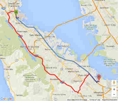
Google is also making all traffic features in its Directions API and Distance Matrix API available under the Standard Plan where you can have up to 2500 requests a day for free. The waypoint limit in Directions API is also being increased from 8 to 23 waypoints. You can use the time prediction by adding a departure_time parameter to queries you create in the Directions API or Distance Matrix API and the results will contain the travel time estimate given the predicted traffic conditions at that time. The API will, under some traffic circumstances, return a route that might be faster given the expected traffic conditions, so you can recommend the fastest route to your users. For example, the image below shows the fastest route from San Francisco International Airport to the Google campus in Mountain View late at night when there’s no traffic (blue), and during peak hour when an accident on Highway 101 has slowed traffic to a crawl (red) |
| Last Updated ( Thursday, 12 November 2015 ) |